Parameterizations and parameter estimation
Parameterization schemes are a major source of systematic errors in numerical weather predictions (NWP). They account for the impact of sub-grid-scale processes that cannot be explicitly represented on a model grid because their characteristic length scales are too small. Parameterized processes include, among others, turbulent exchange in the planetary boundary layer (PBL), the drag exerted on the atmospheric flow by hills and mountains, and the formation and growth of precipitating particles (water drops and ice crystals) in clouds.
Parameter estimation with ensemble methods
Parameterization schemes combine simplified theoretical arguments with semi-empirical relationships. The calibration of parameterization schemes is usually based on limited sets of laboratory experiments, field measurements or idealized high-resolution numerical simulations. Research in our group aims at providing better observational constraints for the uncertain parameters of parameterization schemes. This can be accomplished using ensemble-based data assimilation methods. In the state-and-parameter estimation approach, uncertain model parameters are treated in the same way as model state variables, and are determined in a statistically optimal sense. The parameters estimated by an ensemble are intrinsically flow-dependent and adaptive. The replacement of constant, global parameters by adaptive, local ones can help overcome structural parameterization errors, thereby increasing model skill. Our research in this field is based on idealized Observing System Simulation Experiments (OSSEs). In an OSSE, synthetic observations drawn from a high-resolution simulation of the atmosphere are assimilated into an analysis with coarser resolution. Compared to realistic data assimilation experiments with actual observations and unavoidably imperfect models, OSSEs represent a simplified experimental strategy. Within an OSSE, it is possible to study individual sources of forecast errors in isolation. On the contrary, in realistic experiments multiple sources of errors always co-exist (initial conditions, boundary conditions, different parameterizations, observation operators), substantially complicating the task of estimating optimal parameters.
Idealized experiments with simple models
We conduct experiments with simple models and data-assimilation codes developed in-house and written in Python. We do it mostly in order to create proofs of concept for more complex experiments. With this strategy, we have shown that quickly converged and physically interpretable empirical parameters can be obtained only under restrictive conditions. The most stringent of them is that parametric uncertainty must be the dominant contributor to forecast uncertainty.
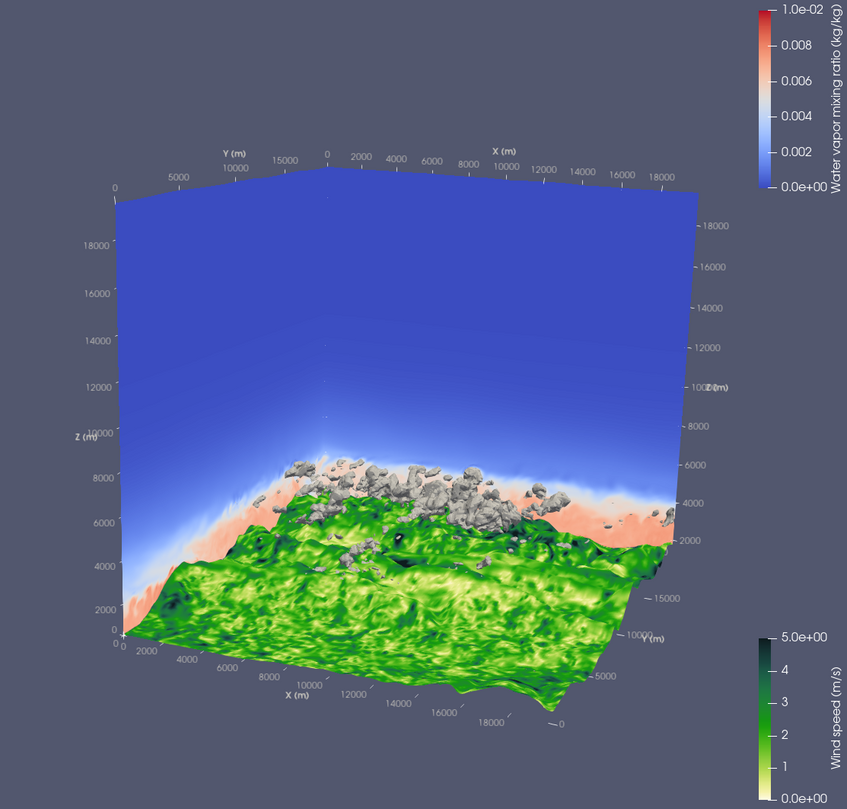
Representation of the planetary boundary layer over complex orography
The planetary boundary layer (PBL) is the part of the atmosphere closest to the ground. Atmospheric flow in the PBL is most often turbulent, and accounts for much of the exchange of energy, momentum and mass between the atmosphere and the land and sea surface. Parameterizations of turbulent exchange are designed to represent the evolution of the PBL over a flat homogeneous surface, but they are known to be inaccurate over mountains. To improve on this, we work on the optimal estimation of mixing lengths, entrainment ratios and non-local transport coefficients. For this application, our OSSEs are based on ensembles of column models of the diurnal convective PBL; the nature runs are large-eddy simulations of thermally-driven cross-valley circulation. Our research in this field is connected with the TEAMx research programme.
Representation of orographic drag
Mountains exert drag on the atmospheric flow in several ways. They generate internal gravity waves, which decelerate the atmospheric flow when breaking; they block low-level stratified flow; and they modulate the pressure field near the surface inducing form drag. Relatively coarse-resolution weather and climate models are unaware of small-scale terrain variability. The drag induced by the unresolved orography must be parameterized in order to prevent wind speed bias. The partitioning between resolved and parameterized drag is very different in different NWP models, suggesting that these parameterizations are poorly constrained and heavily tuned. We work with the two most widely used orographic drag parameterization schemes and study the impact of their empirical parameters on the modelled drag. For these applications, our OSSEs are based on ensembles of two-dimensional simulations of meridional flow over the Alps, while the nature runs are simulations of gravity-wave events observed during TEAMx.
Funding
Our research is funded by:
the FWF (Austrian Science Fund) stand-alone project DEPENDABLE (P 37259), DEmonstrating Parameter Estimation with eNsemble-based Data Assimilation for Boundary-Layer modElling over mountains.
the VISESS Earth PhD Fellowship “Data-driven methods to reduce model errors in numerical weather prediction” awarded by the Vienna International School of Earth and Space Science.
Publications (last updated September 2025)
Serafin, S., and M. Weissmann (2025): Can ensemble-based parameter estimation aid parameterization design? Q. J. R. Meteorol. Soc., in press. DOI: 10.1002/qj.5031.
Code and data