Research Activities
Research Activities
The Geophysics Group is interested in Seismology and Gravimetry.
Seismology
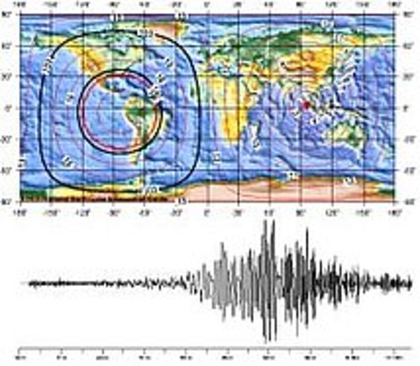
Wave propagation in the Earth and observed seismogram (© IMGW)
Seismology
The geophysics group puts a strong emphasis on seismology. Seismology deals with the propagation of elastic waves through the Earth's interior. The observation, simulation and analysis of such waves gives rise to a wide range of research and industrial applications. In the area of basic research, such observations are the prime means to provide an understanding of the structure and functioning of our planet. Through the observation of earthquakes as well as by determining seismic anisotropy, seismology gives clues on deformation within the Earth. Seismic source processes, as well as caused damaged, are important elements for the assessment of natural hazards, a theme that will be even more important in the future than now. In these areas, we carry out research programs in collaboration with national and international organizations.
In the area of natural resources, seismology makes significant contributions through the mapping of sedimentary layers in 2D or 3D, and monitoring of storage facilities (induced seismicity, 4D imaging, etc).
All these applications are prominently represented in the Vienna area:
The area is an earthquake zone that deforms actively, albeit relatively slowly. Thus, we’d like to better understand seismic hazard in the area. The Vienna Basin is also a hydrocarbon-containing region, which plays an important role for the supply of crude oil and natural gas, hence the prominent presence of various oil companies in the Vienna area, as ultimately the OPEC (Organization of Petroleum Exporting Countries) itself. Another important component of seismology in the Vienna area is the monitoring of nuclear tests, which is carried out by the CTBTO (Comprehensive Test Ban Treaty Organization), and accompanied by national institutions such as the ZAMG (Central Institute for Meteorology and Geodynamics).
Observation of processes in the earth by geophysical methods
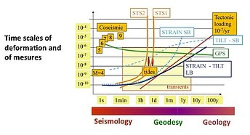
Observation of Earth deformation across different period bands and disciplines of geosciences (© IMGW)
Observation of processes in the earth by geophysical methods
Deformation within the Earth takes place in a very broad period band, and we have seen in recent years that broadband observation of these phenomena provides some new and surprising approaches to well-known, seemingly unsolvable problems in geosciences. An example is the interaction of seismological, geodetic and geological observations in subduction zones, which gives reason for hope to understand the nucleation of large and very damaging earthquakes. The picture shows observation windows of different areas of geoscientific disciplines such as seismology, geodesy, and geology. The combination of observations across these subject boundaries are essential to a better understanding of the dynamics of the Earth. These observations are supported by gravimetry as well as deformation and tilt measurement.
The Conrad observatory on the Trafelberg in the Wienerwald offers excellent conditions for these kinds of observations.
Earthquakes, dynamics of the earth's crust and seismic hazard
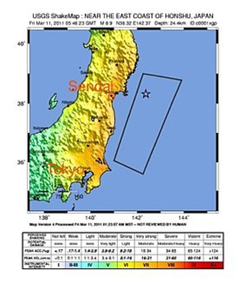
Observed seismic intensity and acceleration by the Tohoku earthquake of 11.03.2011 in Japan ('Shakemap'), copyright IMGW
Observed seismic intensity and acceleration by the Tohoku earthquake of 11.03.2011 in Japan ('Shakemap'), copyright IMGW
Earthquakes, dynamics of the earth's crust and seismic hazard
A major concern is for us to achieve a better understanding of earthquakes, to better understand the dynamics of the Earth's crust in general, and specifically to understand seismic hazard in more detail. This desire is reinforced by recent catastrophic earthquakes and tsunamis (Sumatra 2004, Japan 2011) causing massive material damage and a large number of casualties. Other consequences of such earthquakes concern in particular special buildings such as nuclear power plants.
Although there is no commercial nuclear power in Austria, the country is still not independent from nuclear problems, as there are a number of older nuclear power plants in neighboring countries. Hazard (and more general risk) analysis in and around Austria, also with respect to nuclear power plants, will be a key concern for us for the years to come, and we will perform investigations in that field.
One of the methods used for this purpose is based on intact stalagmites, which have "survived" all earthquake that have occurred in the area over several millenia. That approach requires speleological observations, numerical modeling, but most importantly intact stalagmites in the area.
Geodynamics and forcing of plate tectonics
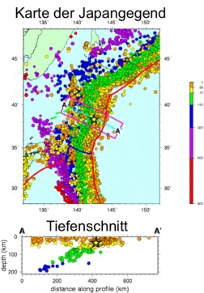
Distribution of earthquakes in Japan (source USGS), copyright IMGW
Distribution of earthquakes in Japan (source USGS), copyright IMGW
Geodynamics and forcing of plate tectonics
We further hope to advance understanding of the basic functioning of our planet. Massively enhanced seismological networks (at least in some areas) will offer us decisive possibilities for that matter. This research has strong potential to provide, in addition to basic knowledge, important new contributions for the application, as to risk research.
An important factor would be the comprehensive determination of the stress state within the Earth, as that would in principle provide prognostic possibilities. Over the last ten years we have performed extensive preparatory work, such as at the San Andreas Fault in California, but also worldwide (driving forces of plate tectonics). One of the specially developed methods is based on seismic anisotropy, and gives constraints on deformation and stress state within the Earth's interior. We are going to use our particular expertise to determine deformation deep under Japan, and to a better understanding of deformations in the wake of the catastrophic Sendai earthquake in 2011. Spatial displacement of mechanical stress will decide where and when further damaging earthquakes will hit.
We also see reason for hope that the number of the outstanding seismological stations that are located in Austria, can be expanded to the density that is now customary on the international scene.
Gravity Field Research
Main research interest concerns spatial and temporal variations of the earth's gravity field in different scales.
Spatial Gravity Variations
Stripped Bouguer gravity map of Northern Tyrol (Austria) calculated by applying a 2D surface density model not taking Quarternary filling of basins and valleys into account. The gravity effect of the upper (0 - 10 km) crust and the Moho boundary according to a 3D model by Ebbbing et al. (2001) has been removed. (© IMGW)
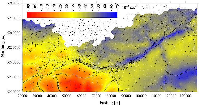
Spatial Gravity Variations
Research is focused on analysis and interpretation of potential field data and on improving data processing methods of gravity field determination.
In cooperation with the Federal Office of Surveying a new Bouguer gravity map of Austria has been compiled based on all available data including those of industrial origin. It serves as a modern and accurate base for gravity field interpretation within the Eastern Alps in order to explore the deep as well as shallow structure of the crust and lithosphere (e.g. crust, isostasy, overdeep valleys etc.)
Temporal Gravity Variations

Gravity variation observed by the SG at Conrad observatory (Austria) caused by heavy rain and convective processes (© IMG)
Temporal Gravity Variations
Research is closely linked to the Global Geodynamcis Project (GGP) (IAG Inter-Commission Project IC-P3.1: Joint with Commission 2 - The Gravity Field, & Commission 3 - Earth Rotation and Geodynamics) that addresses a wide range of geophysical and geodynamic problems:
- inner structure of the earth, the physical properties of the core and its geometry (tidal parameters, NDFW resonance, Slichter triplet, core modes, free oscillation)
- global ocean and atmospheric loading (ocean models, sea level changes, steric effects)
- atmospheric and environmental gravity signals (air mass redistribution and loading, precipitation effects, soil moisture)
- earth rotation
Some of the research fields are closely linked to each other. In cooperation with the Central Institute of Meteorology and Geodynamics (ZAMG) temporal gravity variations are observed since 1995 when the Superconducting Gravimeter (SG) GWR C025 was installed in Vienna and operated during a period of 12 years. In November 2007 the SG was moved to ZAMG’s new Conrad Observatory, a geodynamical research facility situated at 1045 m a.s.l. within the Northern Calcareous Alps. Site-by-Site observations by absolute gravimeters (BEV, ZAMG, Observatory Pecny, University of Luxemburg) and a well calibrated Scintrex gravimeter enabled calculating the calibration factor on the 0.1% accuracy level. As before in Vienna, investigations are focused on environmental gravity effects in different spatial and temporal scales (precipitation, hydrology, atmospheric processes). Identification and modelling of environmental effects on gravity is essential for extracting meaningful geodynamic signals from gravity time series.